Enregistrez gratuitement cette image
en 800 pixels pour usage maquette
(click droit, Enregistrer l'image sous...)
|
|
Réf : T01125
Thème :
Terre vue de l'espace - Villes (375 images)
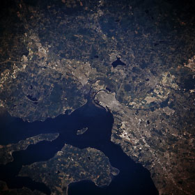
Titre : Everett and Marysville, Washington, U.S.A. Winter 1995-1996
Description : (La description de cette image n'existe qu'en anglais)
Everett, Washington, visible at the center of this east-northeast, low-oblique photograph, is located 28 miles (45 kilometers) north of Seattle at the mouth of the Snohomish River. Everett, a port of entry with a fine natural harbor, is an important lumber-shipping center and has pulp and paper mills. Other enterprises include fisheries, canneries, poultry-packing plants, shipyards, and airplane-manufacturing facilities. The Boeing Corporation facility is discernible south of Everett, just west of Interstate Highway 5, which is visible from near the center to the bottom right of the photograph. The small community of Marysville lies 5 miles (8 kilometers) north of Everett. Parts of narrow, pointed Camano Island and larger Whidbey Island are discernible in Puget Sound west of Everett.
|
|

